4.19 - Discharge & Flow Variation
The definition and measurement of river discharge
River discharge refers to the volume of water passing through a river channel at a given point over a specific time. It is a crucial measure for understanding river behaviour, especially during storm events, and helps in flood prediction and water management.
Key aspects of river discharge
- Volume measurement - Discharge is quantified as the amount of water flowing per second.
- Unit of measurement - It is typically measured in cubic metres per second (m³/s), often abbreviated as cumecs.
The components of storm hydrographs
A storm hydrograph is a graphical representation of how river discharge changes over time in response to a rainfall event. It illustrates the relationship between precipitation and river flow, highlighting critical features that help analyse flood risks.
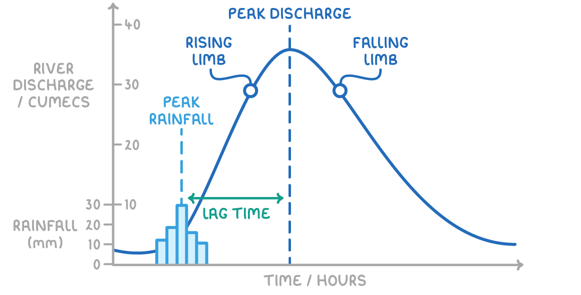
Main features of a storm hydrograph
- Peak discharge - The maximum level of discharge reached during a specific time frame following rainfall.
- Lag time - The time difference between the peak of rainfall and the peak discharge, indicating how quickly a river responds to rain.
- Rising limb - The part of the graph showing an increase in discharge as rainwater enters the river system.
- Falling limb - The section of the graph where discharge decreases, showing the river returning to its baseline flow level.
Water pathways and their impact on discharge
Water reaches rivers through various pathways, each affecting how quickly and in what volume it contributes to river discharge. These pathways determine the speed and quantity of water entering the river system during and after rainfall.
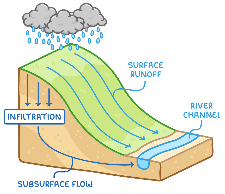
Pathways through which water reaches rivers
- Surface runoff - Water that flows over the land surface directly into the river, often quickly during heavy rain.
- General runoff - A broader term for any water moving over the surface towards the river.
- Infiltration - Water that soaks into the ground, potentially slowing its journey to the river.
- Subsurface flow - Water that, after infiltrating, moves slowly underground before eventually reaching the river channel.
Effects of water pathways on hydrographs
- Runoff dominance - When more water travels as runoff rather than infiltrating, lag time is reduced.
- Discharge increase - Higher volumes of runoff result in greater discharge, creating a steeper rising limb on the hydrograph.
- Timing of water arrival - More water reaching the river in a shorter period accelerates the response time, impacting the overall shape of the hydrograph.
Physical factors affecting storm hydrographs
Several physical characteristics of a drainage basin influence how a river responds to rainfall. These factors affect lag time, the volume of discharge, and the overall shape of the storm hydrograph.
Physical influences on river response
- Geology of the area - Impermeable rocks, such as granite, prevent water infiltration, leading to increased surface runoff and shorter lag times.
- Soil characteristics - Impermeable soils, like clay, absorb less water compared to permeable sandy soils, resulting in more runoff. Shallower soils also saturate faster than deeper ones, further increasing runoff.
- Slope gradient - Steeper slopes reduce infiltration as water flows downhill quickly, boosting runoff and reducing lag time.
- Drainage basin shape - Circular basins tend to have shorter lag times and higher peak discharges because water from different areas reaches the main channel simultaneously. In contrast, narrow, elongated basins have longer lag times as water from distant parts takes longer to arrive at the main river.
Human and antecedent impacts on hydrographs
Beyond physical factors, human activities and prior environmental conditions also play significant roles in shaping storm hydrographs. These elements can alter how water moves through a landscape and affect river discharge patterns.
Impact of antecedent conditions
- Prior weather effects - Wet or very cold preceding weather increases runoff. Saturated soils cannot absorb more water, and frozen ground prevents infiltration, both leading to quicker and higher discharge.
- Soil saturation - When soils are already waterlogged from earlier rainfall, additional rain flows directly as runoff, shortening lag time.
Influence of human activities
- Urbanisation - In urban areas, impermeable surfaces like concrete and asphalt prevent water from soaking into the ground, increasing surface runoff. Urban drainage systems, such as gutters and drains, rapidly channel water to rivers, causing a sharp rise in discharge.
- Deforestation - Trees naturally absorb and store water, reducing runoff. When forests are removed, runoff increases significantly, leading to higher river discharge and a faster response time on the hydrograph.