4.1 - UK Physical Landscape: Introduction
The general characteristics of the UK physical landscape
The United Kingdom has a diverse physical landscape shaped by geological processes over millions of years. The UK can be divided into two primary types of areas: upland and lowland regions, each with distinct physical features and uses.
Main elements of the UK landscape
- Mountains - Found predominantly in upland areas, these are often steep and rocky, contributing to the rugged scenery in certain regions.
- Coasts - The UK's extensive coastline features cliffs, beaches, and estuaries, shaped by erosion and deposition processes.
- Rivers - Numerous rivers crisscross the landscape, playing a vital role in shaping valleys and supporting ecosystems and human activity.
The distribution of upland and lowland areas in the UK
The UK's landscape is not uniform, with a clear divide between upland and lowland areas based on their geographical location. This distribution influences climate, population density, and land use across the country.
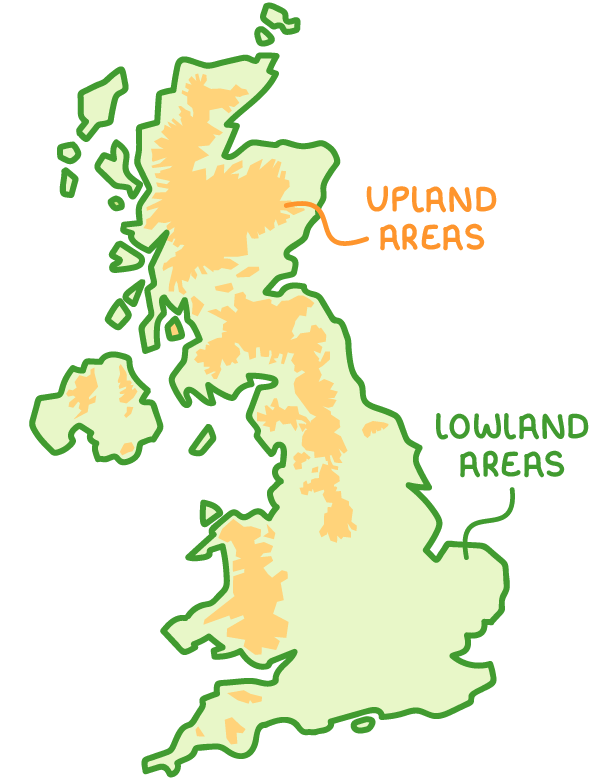
Geographical spread of upland and lowland regions
- Upland areas - These are generally located in the north and west of the UK, encompassing regions with higher elevation and more challenging terrain. On landscape maps, they are often shown in orange and red hues.
- Lowland areas - These are typically situated in the south and east, characterised by flatter, more accessible land. They are represented in green on maps, indicating lower elevation and gentler topography.
Major upland regions and their features
Upland areas in the UK are known for their dramatic landscapes, often formed by ancient geological activity such as volcanic eruptions and glaciation. These regions are sparsely populated due to their harsh conditions but are significant for their natural beauty and resources.
Prominent upland areas in the UK
- Grampian Mountains - Located in the Scottish Highlands, this area includes some of the most rugged terrain in the UK.
- Ben Nevis - Standing as the highest peak in the UK, located within the Grampian range.
- Pennines - Often referred to as the 'backbone of England', this range stretches across northern England.
- Lake District - Found in northwest England, known for its lakes and mountains.
- Mourne Mountains - Situated in Northern Ireland, these mountains are a key part of the region's landscape.
- Upland characteristics - These areas typically have steep, rocky terrain, making them less suitable for settlement and agriculture, resulting in sparse populations.
Key rivers and water features across the UK
Rivers and water bodies are integral to the UK's physical geography, shaping the landscape through erosion and deposition, and providing essential resources for human and ecological systems.
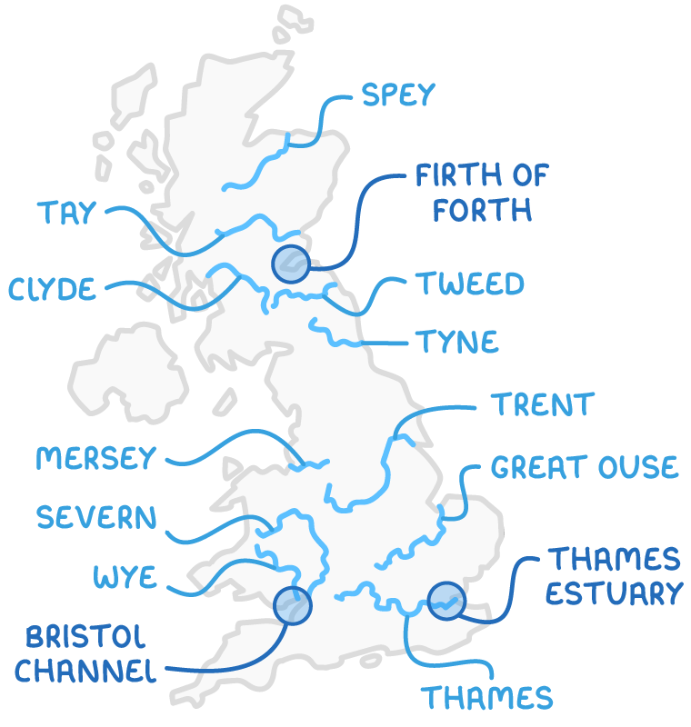
Significant rivers by region
- Northeast and Scotland - Includes the Spey, Tay, Tweed, and Tyne.
- West Scotland - The Clyde, a major river in the region.
- Northwest England - The Mersey.
- Midlands and East England - The Trent and Great Ouse.
- Southeast England - The Thames, running through London.
- West England and Wales - The Severn and Wye, with the Severn being the longest river in the UK.
Notable water features
- Firth of Forth - A large estuary in eastern Scotland.
- Bristol Channel - A major inlet in the southwest, separating Wales from England.
- Thames Estuary - Located at the mouth of the Thames in southeast England.
Examples of lowland and upland landscapes
The UK's diverse landscapes can be illustrated through examples of lowland and upland areas, each showcasing unique features formed by natural processes.
Lowland plains landscape
- Formation - Characterised by low, flat terrain created by the deposition of materials eroded by glaciers over time.
- Soil quality - Features fertile soil, making it ideal for agricultural activities.
- Primary use - Predominantly used for dairy farming due to the suitability of the land for grazing and crop production.
Lowland valley landscape
- Topography - Comprises wide valleys situated between parallel hills, with gentle, rolling slopes.
- Historical context - Originally covered by extensive forests, which have largely been cleared over centuries.
- Current use - Mainly agricultural, taking advantage of the accessible and fertile land for farming.
Glaciated upland landscape
- Formation - Shaped by rock from extinct volcanoes, with features sculpted by glacial activity.
- Physical features - Includes steep mountains and glaciated valleys, often with deep depressions that may be filled with water, forming lakes.
- Land use challenges - The rugged terrain limits intensive human activity.