4.17 - How to Identify River Landforms
Understanding contour lines and their relation to river flow
Contour lines are essential features on maps that represent the height and steepness of land. These orange lines help in understanding the topography of an area, particularly how rivers interact with the landscape due to gravitational forces.
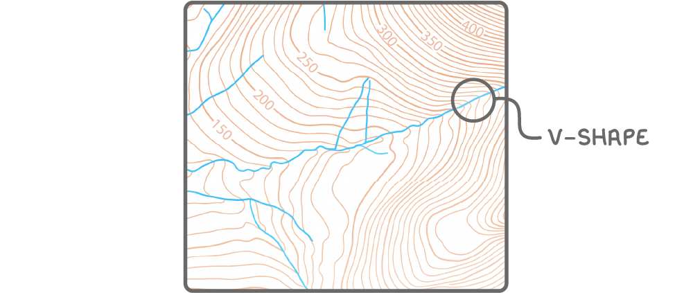
Key features of contour lines and river direction
- Height representation - Contour lines indicate the elevation of land in metres above sea level, with numbers printed on them showing the specific height.
- Steepness indicator - The closer the contour lines are to each other, the steeper the slope of the land.
- Direction of slope - Heights generally decrease towards the west (left side of a map), meaning the land slopes downhill in that direction.
- River flow patterns - Rivers flow from areas of higher elevation to lower elevation, following the natural gradient shown by decreasing contour line values.
- V-shaped patterns - When contour lines cross a river, they form a V-shape. The point of the V always indicates the uphill direction, showing where the river originates.
Identifying upper course river features on maps
The upper course of a river is typically found in higher elevation areas with steep gradients. Maps reveal distinct characteristics that help identify this section of a river's journey.
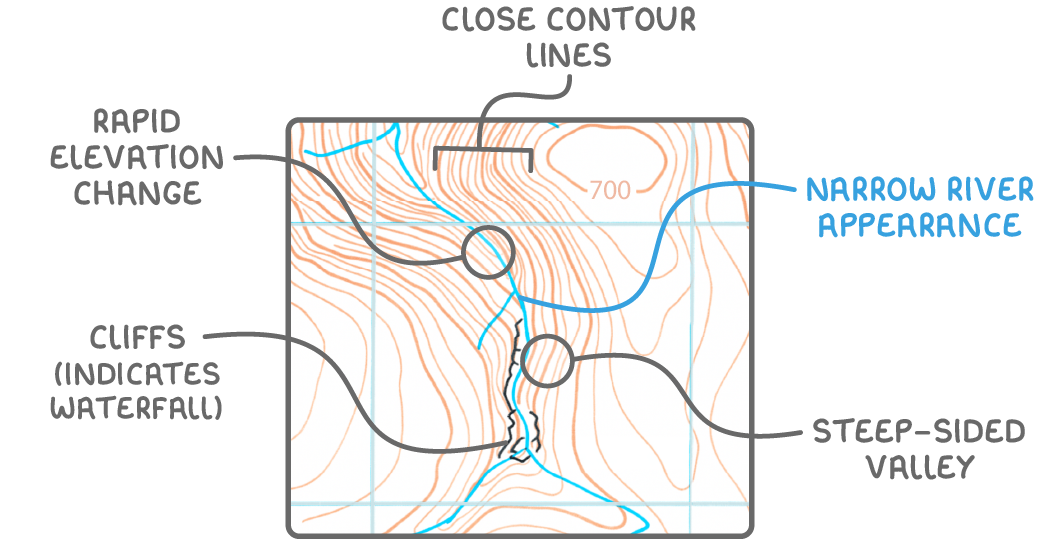
Indicators of upper course river features
- Presence of waterfalls - Marked directly on maps or suggested by symbols like black, blocky lines representing cliffs.
- Steep terrain - Close contour lines near the river indicate a rapid change in height over a short distance, often linked with waterfalls or steep drops.
- High elevation - Land in the upper course is often at significant heights, such as over 700 metres.
- Narrow river channel - Represented by a thin blue line on maps, indicating the river is not yet wide or deep.
- Steep-sided valleys - Very close contour lines with a narrow valley floor suggest steep, V-shaped valleys typical of the upper course.
- Rapid descent - The river crosses numerous contour lines over a short map distance, highlighting a steep gradient.
Recognising lower course river features on maps
The lower course of a river is found in areas of low elevation with gentle slopes. Maps provide clear evidence of the river's characteristics as it nears its end, often close to the sea or a lake.
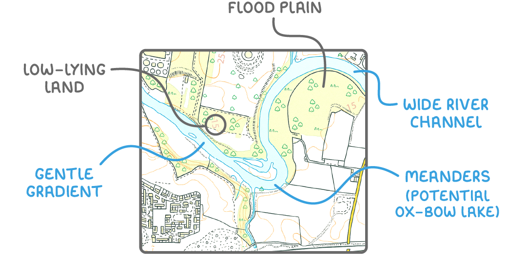
Indicators of lower course river features
- Low elevation - Land is typically below 15 metres, showing a flat or gently sloping landscape.
- Gentle gradients - The river does not cross many contour lines, indicating a slow descent over a wide area.
- Meandering path - Large, looping bends in the river's course, visible as wide curves in the blue line on maps.
- Flood plain presence - Absence of contour lines around the river suggests a flat flood plain, prone to flooding.
- Wide river channel - Represented by a thick blue line on maps, indicating a broader and deeper river.
- Ox-bow lake potential - Tight meanders may be cut off over time, forming isolated loops of water known as ox-bow lakes, sometimes visible near the river's path.
Using map evidence to identify river landforms
Maps are crucial tools for identifying various landforms created by rivers in different stages of their course. By combining contour lines, elevation data, and river symbols, distinct features can be recognised.
Common river landforms on maps
- Waterfalls in upper course - Indicated by close contour lines, cliff symbols, or specific waterfall markings, showing areas of sudden height change.
- V-shaped valleys in upper course - Identified by tightly packed contour lines forming a V-shape where they cross the river, pointing uphill to the source.
- Meanders in lower course - Visible as wide, curving paths of the river across flat terrain with minimal contour line interference.
- Flood plains in lower course - Recognised by large flat areas around the river with few or no contour lines, suggesting a wide area of potential flooding.
- Ox-bow lakes in lower course - Appear as small, curved bodies of water near the river, formed from cut-off meanders and often marked as separate blue features on maps.