12.2 - Glacial Landforms
The occurrence and impact of glacial periods in the UK
Glacial periods, often referred to as ice ages, have played a significant role in shaping the Earth's landscapes over the past 2.6 million years. During these cold phases, vast ice sheets extended across parts of the UK, dramatically altering the terrain through various geological processes.
Key features of glacial periods in the UK
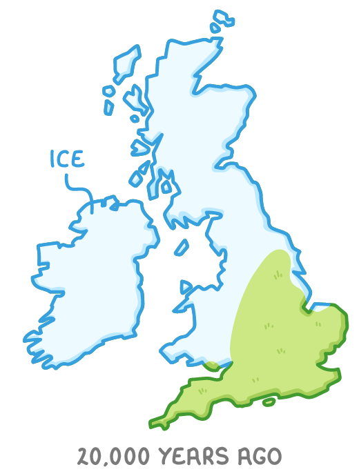
- Historical context - Multiple ice ages have occurred over the last 2.6 million years, with significant coverage of the UK by massive ice sheets during these times.
- Peak ice coverage - The most extensive ice cover during the last glacial period happened approximately 20,000 years ago, affecting large areas of the British Isles.
- Landscape transformation - Upland areas in the UK have been profoundly shaped by ice through processes like erosion, transportation of materials, and deposition, creating distinctive landforms.
Erosional landforms created by glacial activity
Glaciers are powerful agents of erosion, carving out unique features in the landscape as they move and interact with the underlying rock. These erosional landforms are characteristic of areas once covered by ice and are often found in upland regions.
Types of erosional glacial landforms
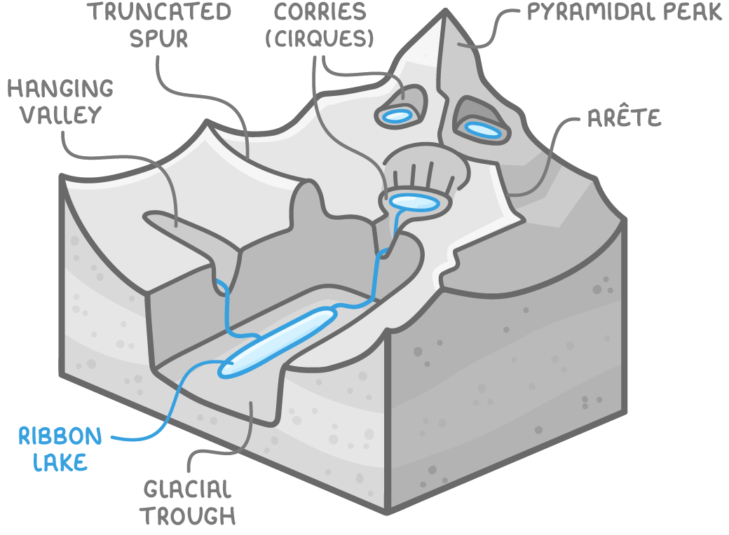
- Arête - A sharp, narrow ridge with steep sides, formed when two glaciers erode parallel valleys, sharpening the land between them into a jagged edge.
- Pyramidal peak - A pointed mountain summit with at least three steep sides, created by the erosion of a mountain by three or more glaciers converging from different directions.
- Corries (cirques) - Steep-sided, armchair-shaped hollows formed by rotational slip of a small glacier. After the ice melts, a small circular lake called a tarn may remain behind a lip at the lower end.
- Ribbon lakes - Long, narrow lakes formed in hollows after a glacier retreats, where softer rock has been eroded more deeply than the surrounding harder rock.
- Truncated spurs - Steep, cliff-like edges on valley sides, formed when a glacier cuts off the protruding ridges of land (spurs) as it moves through a valley.
- Hanging valleys - Smaller valleys left at a higher elevation than the main valley floor, formed by tributary glaciers that erode less deeply compared to the main glacier.
- Glacial troughs - Wide, steep-sided valleys with flat bottoms, originally V-shaped river valleys transformed into a U-shape by glacial erosion of the sides and floor.
Depositional landforms formed by melting glaciers
As glaciers melt, they deposit the materials they have carried, creating various landforms. These depositional features provide evidence of past glacial activity and are often found in both upland and lowland areas.
Categories of depositional glacial landforms
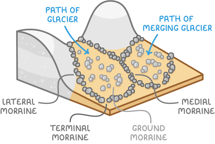
- Moraines - Accumulations of till (glacial debris) deposited by melting glaciers, categorised by their location in the valley:
- Lateral moraine - A long mound of material along the valley sides, made of debris eroded from the valley walls and carried on the glacier's surface edges.
- Medial moraine - A central ridge of material in the valley floor, formed when lateral moraines from two merging glaciers combine into a central line.
- Terminal moraine - Semicircular mounds at the glacier's furthest advance, marking the snout where transported material is deposited as the ice retreats.
- Ground moraine - Widespread deposits over the valley floor, consisting of material dragged along the glacier's base and left behind as it melts.
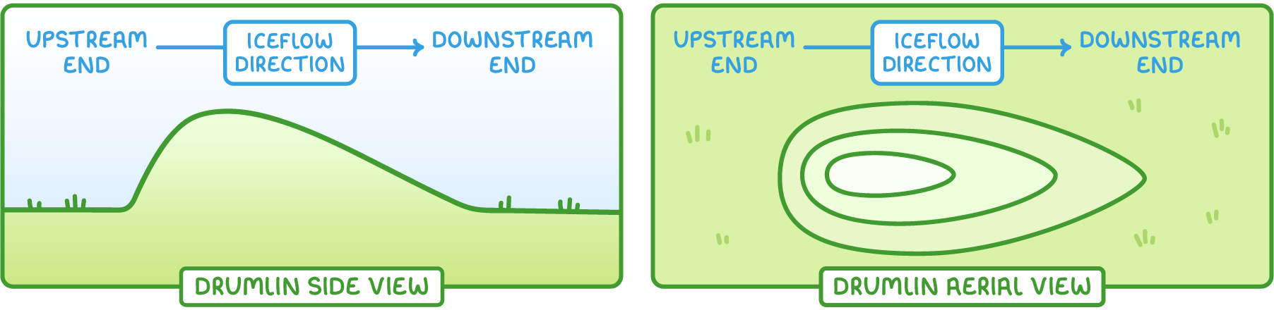
- Drumlins - Elongated hills formed from material deposited by overloaded or melting glaciers. Shaped by continuing ice flow, they are blunt and steep at the upstream end, and tapered and gently sloping downstream, with some reaching up to 1000 m in length, 500 m in width, and 50 m in height.
- Erratics - Large rocks transported by glaciers and dropped in areas with different rock types, often appearing out of place, such as a solitary boulder in an otherwise uniform landscape.
The role of ice in shaping upland landscapes
Ice has been a dominant force in sculpting upland areas of the UK, using a combination of erosional and depositional processes. The interaction of glaciers with the landscape has created a variety of features that define these regions.
Processes of glacial landscape formation
- Erosion - Glaciers wear away rock through abrasion and plucking, carving out features like corries, arêtes, and glacial troughs, significantly altering valley shapes and mountain profiles.
- Transportation - Ice carries debris ranging from fine sediment to large boulders over long distances, redistributing materials across the landscape, as seen in the placement of erratics.
- Deposition - As glaciers melt, they leave behind the transported materials, forming landforms such as moraines and drumlins, which provide clues about the extent and movement of past ice sheets.
These processes together illustrate the transformative power of ice, leaving behind a legacy of dramatic and distinctive landforms in upland areas that continue to shape the natural environment of the UK.