11.5 - River Landforms from Deposition
The formation and characteristics of flood plains
Flood plains are extensive, flat areas of land adjacent to a river that are prone to flooding. These landforms are a key feature of a river's lower course, where the river's energy decreases, leading to the deposition of transported materials.
How flood plains are formed
- Flooding events - During floods, water overflows the river banks, spreading across the wide valley floor.
- Loss of energy - As the water spreads out, its speed reduces, causing it to lose energy.
- Deposition of material - With reduced energy, the river deposits sediment, such as silt and sand, across the flooded area.
- Gradual build-up - Repeated flooding events add layers of sediment over time, gradually building up the height and extent of the flood plain.
Characteristics of flood plains
- Wide valley floor - Flood plains form a broad, flat expanse on either side of the river, creating a wide valley.
- Meander migration - Meanders, or bends in the river, move laterally across the flood plain, widening it over time.
- Downstream movement - Meanders also shift downstream, further shaping the flood plain.
- Slip-off slope deposition - Sediment is deposited on the inner bends of meanders (slip-off slopes), contributing to the flood plain's development.
Development of natural levees
Levees are naturally formed raised banks that run parallel to the edges of a river channel. They develop through repeated flooding and deposition, acting as barriers that can influence the river's behaviour during floods.
How levees are formed
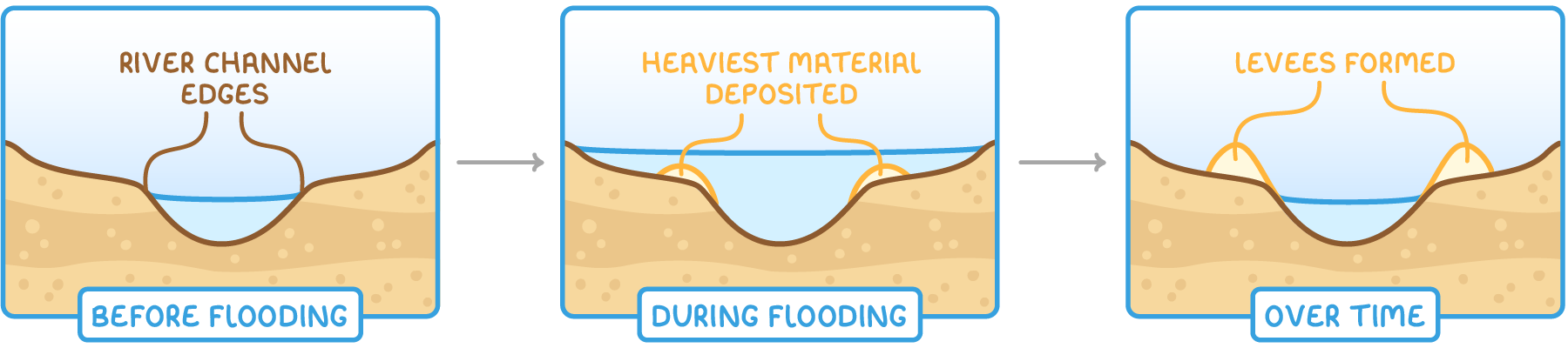
- Flooding and deposition - When a river floods, it carries eroded material across the flood plain.
- Heaviest material first - As the water loses energy, the heaviest particles are deposited closest to the river channel, since they are dropped first.
- Build-up over time - With each flood, more material accumulates near the channel edges, gradually raising the banks to form levees.
- Natural embankment - These deposits create a natural embankment that stands higher than the surrounding flood plain.
Characteristics of levees
- Raised banks - Levees appear as elevated ridges along the river's edges, formed by sediment build-up.
- Proximity to channel - They are located immediately next to the river, marking the boundary between the channel and the wider flood plain.
Features and formation of estuaries
Estuaries are unique tidal zones where a river meets the sea, marking the transition from freshwater to saltwater environments. Found at the river's mouth, they are shaped by both river and tidal processes.
How estuaries are formed
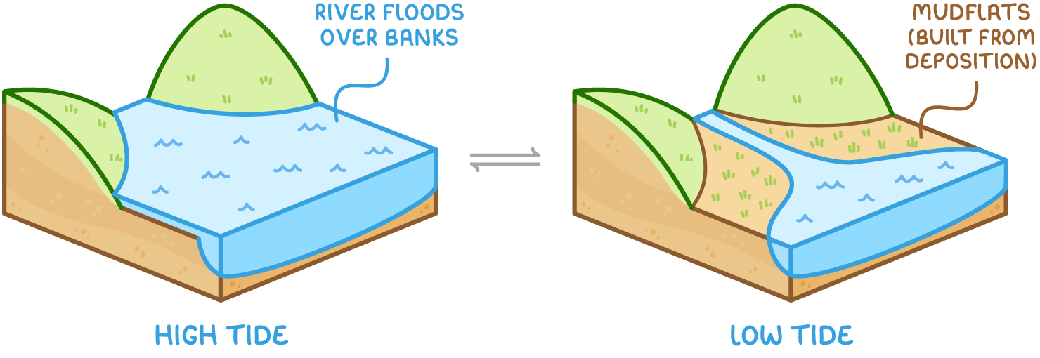
- Tidal influence - The river's flow interacts with daily tidal movements, causing the water level to rise and fall.
- Flooding over banks - During high tides, water floods over the river banks, carrying fine sediment like silt and sand onto the valley floor.
- Sediment deposition - At the peak of the tide, water movement slows, losing energy and depositing sediment across the area.
- Mudflat development - Over time, repeated deposition builds up extensive mudflats, which are exposed during low tide.
Characteristics of estuaries
- Wide valley - The river valley is at its widest here, with land close to sea level.
- Tidal nature - The water level fluctuates daily due to tides, creating a dynamic environment.
- Muddy banks - Large, muddy expanses are visible at low tide, formed by the accumulation of fine sediment.
Traits of lower course depositional landforms
Depositional landforms such as flood plains, levees, and estuaries share several key characteristics due to the similar processes that create them. These features are predominantly found in the lower reaches of a river's journey.
Shared features of depositional landforms
- Lower course location - All these landforms are typically located in the lower course of a river, where the gradient is gentle, and the river's energy is reduced.
- Energy loss - They form as the river slows down, losing the energy needed to carry its sediment load.
- Sediment deposition - The primary process behind their formation is the dropping of transported material, such as sand, silt, and mud, when the river can no longer sustain its load.
- Dynamic evolution - These landforms evolve over time through repeated cycles of flooding and deposition, shaping the river's landscape.