11.6 - How to Identify River Landforms on a Map
The use of contour lines to identify river features
Contour lines are essential tools on maps for understanding the landscape through which a river travels. These orange lines provide critical information about the terrain and help in identifying key river features.
Key functions of contour lines
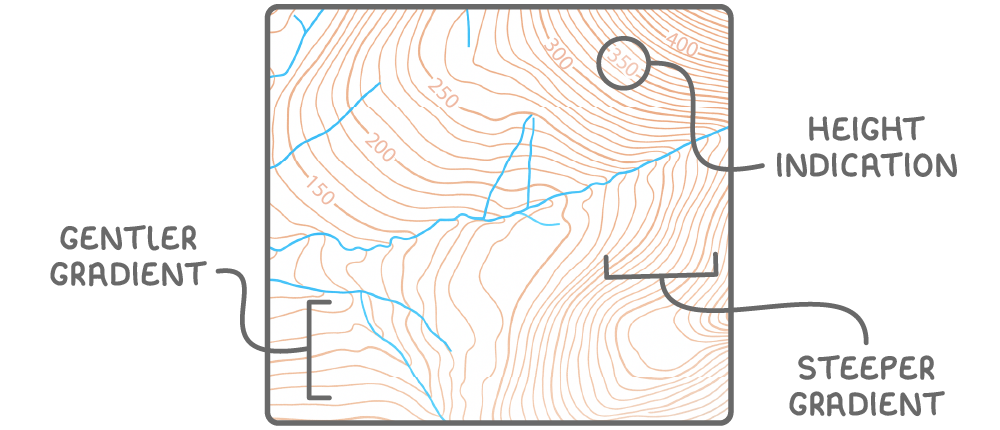
- Height indication - Numbers on contour lines show the elevation of the land in metres above sea level.
- Slope steepness - The closer the contour lines are to each other, the steeper the slope of the land; widely spaced lines indicate a gentler gradient.
Principles of river flow direction
Rivers follow a predictable pattern of movement influenced by the topography of the land.
Rules governing river flow
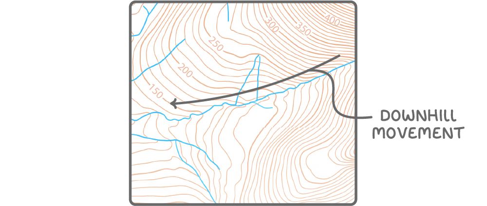
- Downhill movement - Rivers always flow from higher to lower ground, following the natural gradient of the landscape.
- Contour line progression - On a map, rivers move from higher-numbered contour lines to lower-numbered ones, indicating a descent in elevation.
- Directional clue - If contour values decrease towards a specific direction, such as west, it means that direction is downhill, and the river flows that way.
Recognising V-shaped valleys on maps
Certain formations on maps provide clues about the river's journey through different terrains. One prominent feature is the V-shaped valley, often seen in specific sections of a river's course.
Identifying V-formations
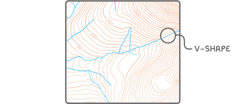
- Contour line pattern - When contour lines cross a river and form a V-shape, this indicates a steep-sided valley.
- Direction of the V - The point of the V-shape always points uphill, showing the direction from which the river has flowed.
Evidence of river landforms in the upper course
The upper course of a river, typically located in higher, mountainous areas, exhibits distinct characteristics that can be identified on maps through specific map symbols and contour patterns.
Indicators of upper course features
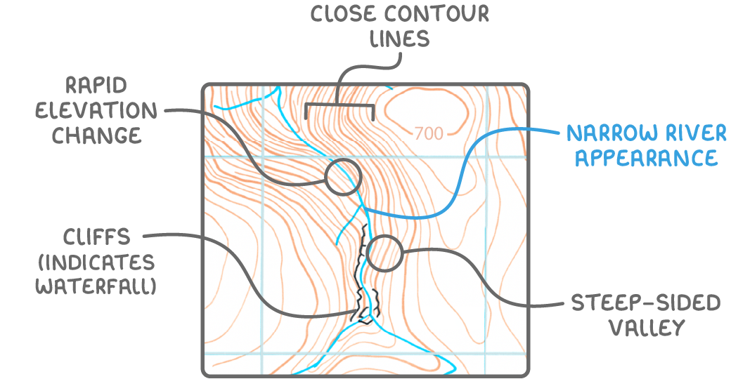
- Waterfall symbols - Marked on maps with black, blocky lines representing a cliff, often indicating the presence of a waterfall.
- Close contour lines - Suggest steep terrain, common near waterfalls in the upper course, with land elevations often high, for instance, around 700 m.
- Rapid elevation change - The river crosses multiple contour lines over a short distance, highlighting a sharp drop in height.
- Narrow river appearance - Represented by a thin blue line on maps, indicating the river's early, narrower stage.
- Steep-sided valleys - Contour lines are tightly packed, showing a narrow valley floor and steep valley walls, often forming a V-shape.
Evidence of river landforms in the lower course
As a river progresses to its lower course, closer to the sea, the landscape flattens, and the river's characteristics change. These features are also identifiable on maps through distinct visual cues.
Indicators of lower course features
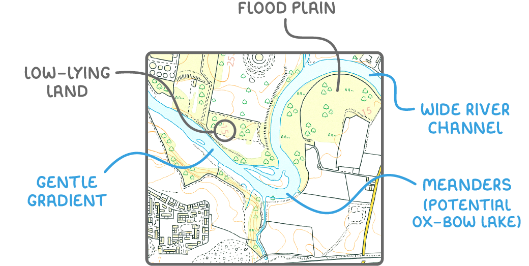
- Low-lying land - The surrounding terrain is at a low elevation, often below 15 m, indicating proximity to sea level.
- Flood plain presence - The river meanders across a broad, flat area with no contour lines, representing a flood plain.
- Wide river channel - Shown as a thick blue line on maps, reflecting the river's increased width in its later stages.
- Gentle gradient - The river does not cross contour lines, indicating a very slight slope as it nears its end.
- Meandering path - Large, looping curves in the river's path, known as meanders, are common in the lower course.
- Ox-bow lake formation - These crescent-shaped lakes may appear near meanders, formed when a river cuts off a loop in its path.