11.7 - Rainfall, Discharge & Flooding
The concept of river discharge and its measurement
River discharge refers to the volume of water passing through a specific point in a river over a given time. It is a crucial measure for understanding river behaviour and assessing flood potential in various environments.
Discharge is quantified in cubic metres per second, often abbreviated as cumecs (m³/s), indicating the amount of water flowing through a river section.
Monitoring discharge helps predict flooding events and manage water resources effectively by providing data on how much water a river carries at any time.
The components and purpose of hydrographs
Hydrographs are graphical tools used to illustrate how river discharge changes over time, especially in response to rainfall events. They provide valuable insights into the timing and magnitude of water flow in a river system.
Main elements of a hydrograph
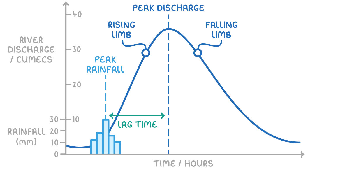
- Peak discharge - The highest level of discharge recorded during a specific period, indicating the maximum water flow in the river.
- Lag time - The time difference between the peak of rainfall and the peak discharge, reflecting the delay in water reaching the river channel.
- Rising limb - The segment of the hydrograph showing an increase in discharge as rainwater enters the river, representing a rapid rise in water levels.
- Falling limb - The part of the graph where discharge decreases, marking the river's return to its baseline flow after the rainfall event.
Role of hydrographs
Hydrographs are essential for analysing how rainfall influences river flow and for identifying patterns that could lead to flooding.
Pathways of water flow into rivers
Water does not instantly reach a river channel after rainfall. Instead, it follows distinct routes, which affect the speed and volume of water entering the river, influencing discharge and flood risk.
Primary routes of water movement
- Surface runoff - Water flows over the land surface directly into the river, a rapid process that increases discharge quickly after rainfall.
- Infiltration - Water seeps into the soil and moves slowly underground towards the river, a slower pathway that delays the increase in discharge.
Impact on lag time
The lag time observed in hydrographs exists because most rainfall does not land directly in the river. The balance between surface runoff and infiltration determines how quickly water reaches the channel, with more runoff leading to shorter lag times and faster rises in discharge.
Physical factors influencing flood risk
Flooding happens when a river's water level exceeds its banks, spilling over into surrounding areas. Several natural factors can heighten this risk by reducing lag time and increasing peak discharge.
Natural contributors to flooding
- Heavy rainfall - Intense downpours deliver water faster than the ground can absorb it, resulting in significant surface runoff that boosts river discharge.
- Geology and soil type - Impermeable materials like clay soils or rocks such as marble and quartzite prevent water infiltration, forcing more water to flow overland into rivers.
- Prolonged rainfall - Extended periods of rain can saturate the soil, preventing further absorption, so additional rain becomes runoff, elevating discharge levels.
- Relief and terrain - Steep landscapes, such as narrow canyons, allow water to travel swiftly down slopes to the river, accelerating the rise in discharge and shortening lag time.
Human factors contributing to flood risk
Human activities can significantly alter the natural flow of water, often increasing the likelihood of flooding by changing land surfaces and water management practices.
Human-induced risks for flooding
- Urban development - Cities and towns with impermeable surfaces like concrete and asphalt prevent water infiltration, increasing surface runoff. Artificial drains also speed up the delivery of water to rivers, raising discharge rapidly.
- Vegetation changes - Trees naturally intercept rainfall on their leaves, allowing some to evaporate, while also absorbing water from the soil. Deforestation removes this natural barrier, leading to a greater volume of water reaching the river channel, thus heightening flood risk.