10.2 - Coastal Landforms
Concordant and discordant coastlines
Coastal landforms are shaped by the interaction of erosion and deposition processes along the shoreline. The structure of the coastline itself plays a significant role in determining the types of landforms that develop, primarily through the arrangement of rock types.
Characteristics of concordant and discordant coastlines
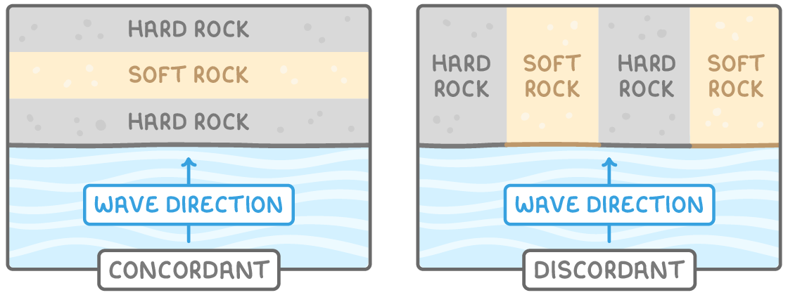
- Concordant coastlines - These occur where bands of hard and soft rock run parallel to the coast.
- Discordant coastlines - Alternating bands of hard and soft rock are positioned at right angles to the coast. This leads to differential erosion, creating varied landforms such as headlands and bays due to the differing resistance of the rocks.
Rock properties influencing erosion rates
- Hardness of rock - Hard rocks, such as granite, resist erosion and erode slowly, while softer rocks, like sandstone, wear away more quickly under wave action.
- Structural weaknesses - Rocks with joints, faults, or other weaknesses are more susceptible to erosion, as these flaws provide pathways for waves to exploit and break down the material faster.
Headlands, bays, and wave-cut platforms
Discordant coastlines are particularly notable for the formation of distinctive landforms due to varying erosion rates. Headlands, bays, and wave-cut platforms are key features shaped by the relentless action of waves.
Development of headlands and bays
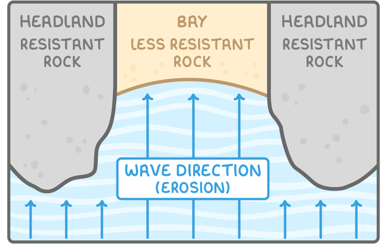
- Location - These form on discordant coastlines where resistant and less resistant rock bands alternate.
- Erosion process - Less resistant rock erodes more rapidly, forming a bay with a gently sloping shoreline. Meanwhile, the more resistant rock withstands erosion longer, protruding into the sea as a headland with steep, rugged sides.
Erosion sequence leading to headland features
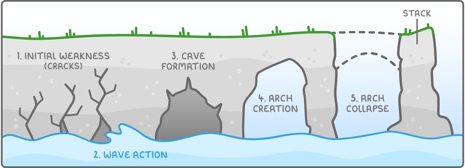
- Initial weaknesses - Headlands, made of resistant rock, often have cracks or joints that waves exploit.
- Wave action - Waves crash against the headland, enlarging these cracks through hydraulic power (force of water) and abrasion (rubbing by sediment).
- Cave formation - Continuous wave action deepens the cracks into a cave.
- Arch creation - Further erosion extends the cave until it breaks through the other side, forming a natural arch.
- Arch collapse - Over time, the arch weakens and collapses due to ongoing erosion, leaving an isolated rock formation known as a stack, detached from the headland.
Formation of wave-cut platforms
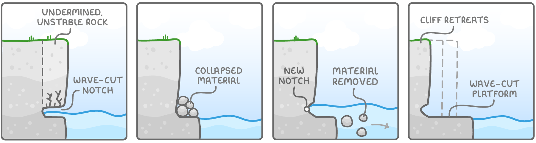
- Wave impact - Waves focus their erosive power at the base of a cliff, carving out a wave-cut notch.
- Cliff instability - Repeated erosion undermines the rock above the notch, causing it to become unstable and eventually collapse.
- Material removal - The debris from the collapse is washed away by the sea, and a new notch begins to form at the cliff base.
- Cliff retreat - This cycle of erosion and collapse repeats, causing the cliff to retreat inland and leaving behind a flat, rocky area called a wave-cut platform.
The development of beaches, spits, and bars
Deposition processes along coastlines create various landforms where sediment is accumulated. Beaches, spits, and bars are significant features formed by the movement and settling of materials like sand and shingle.
Types and formation of beaches
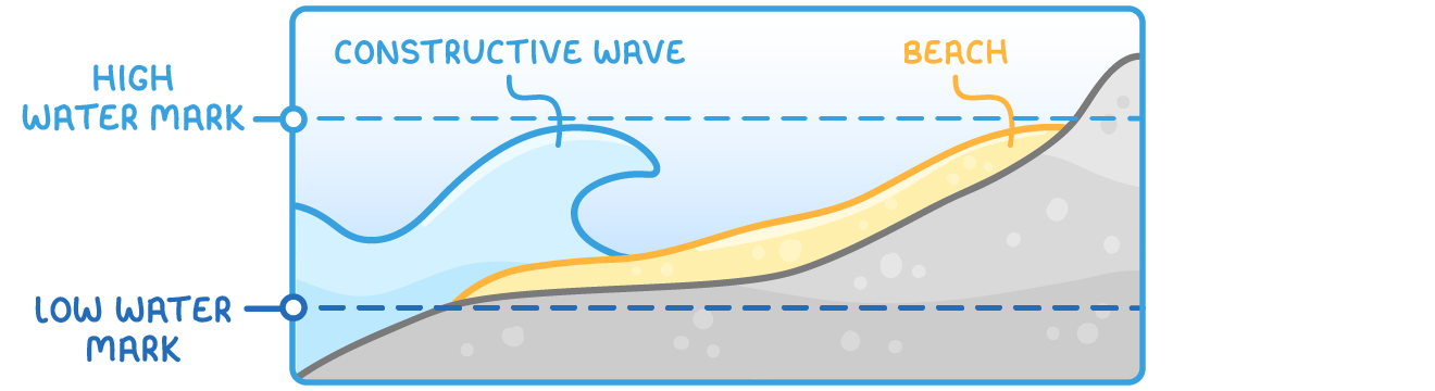
- Location - Beaches are found between the high and low water marks along the coast.
- Constructive waves - These constructive waves deposit material, building up the beach over time.
- Sand beaches - Formed by low-energy waves, these are flat and wide with gentle slopes. The weak backwash struggles to move small sand particles far, allowing them to accumulate.
- Shingle beaches - Created by high-energy waves, these are steep and narrow. Smaller particles are washed away, leaving larger shingle to build up.
Process of spit formation
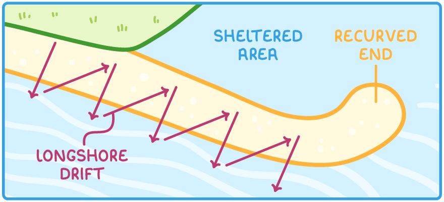
- Starting point - Spits form at sharp bends in the coastline, often near river estuaries.
- Longshore drift - This longshore drift process transports sediment along the coast and deposits it past the bend, creating a narrow strip of land extending into the sea.
- Recurved end - Strong winds and waves can bend the tip of the spit, forming a curved end.
- Sheltered area - Behind the spit, a calm zone develops where material accumulates, and vegetation may grow, sometimes leading to the creation of mud flats or salt marshes.
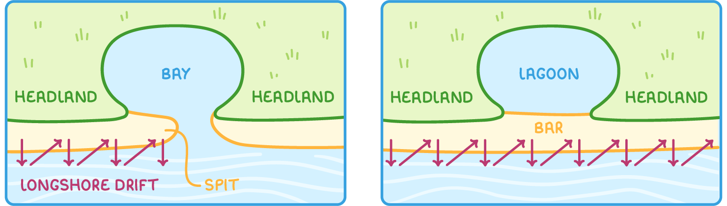
Creation of bars
- Connection of headlands - A bar forms when a spit extends across a bay to join two headlands, cutting off the bay from the sea and forming a lagoon behind it.
- Offshore bars - On gently sloping coasts, friction slows waves down, causing sediment to be deposited offshore, creating bars parallel to the shoreline but detached from it.
The process of sand dune formation
Sand dunes are dynamic landforms created by wind action on coastal sediments. They evolve through distinct stages and are stabilised by vegetation over time.
Stages of sand dune development
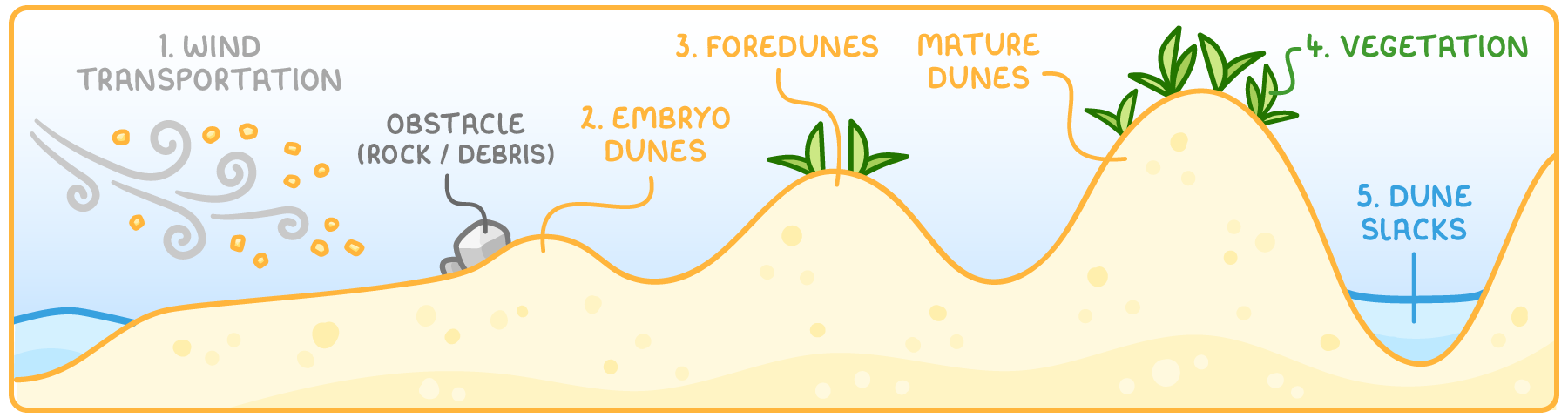
- Wind transportation - Wind carries sand from the beach inland, depositing it when speed decreases due to obstacles like rocks or debris.
- Embryo dunes - Initial small mounds of sand form as deposition begins.
- Foredunes and mature dunes - As more sand accumulates, dunes grow into foredunes and eventually mature dunes, increasing in height and stability.
- Role of vegetation - Plants such as Marram grass colonise the dunes, with their roots binding the sand and encouraging further accumulation.
- Dune slacks - Small pools or hollows, known as dune slacks, form in the low areas between dunes, often holding water.
Identifying coastal features on maps
Representation of coastal features on maps
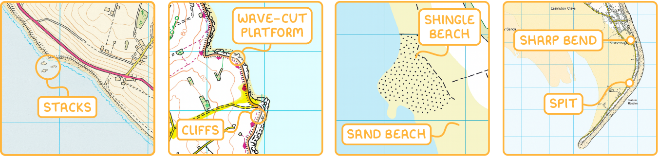
| Feature | Map representation |
|---|---|
| Caves and arches | These are not visible on maps because they are often hidden under overlying rock. |
| Stacks | Appear as small islands or dark blobs in the sea, indicating isolated rock formations. |
| Cliffs | Shown as thick black lines along the coastline, representing steep drops. |
| Wave-cut platforms | Indicated by irregular, bumpy edges along the coast, showing flat eroded areas. |
| Sand beaches | Coloured in pale yellow to signify wide, sandy areas. |
| Shingle beaches | Depicted in white or yellow with speckles to represent coarse, pebbly surfaces. |
| Spits | Illustrated as narrow extensions of beach material into the sea, connected to the land at one end. |