4.8 - How to Identify Coastal Landforms
Categories of coastal landforms: erosional and depositional features
Coastal landforms are shaped by the dynamic processes occurring along coastlines. They can be broadly classified into two main types based on the processes that create them: erosional and depositional.

Types of coastal landforms
- Erosional landforms - These are formed by the wearing away of coastal rock and soil through processes like wave action, weathering, and abrasion. Examples include cliffs and stacks.
- Depositional landforms - These are created by the accumulation of sediment and materials carried by waves, currents, and winds. Examples include beaches and spits.
Identifying erosional landforms on maps
Erosional landforms are features sculpted by the forces of erosion along coastlines. Maps are essential tools for identifying these features, though not all can be directly seen due to their location or scale.
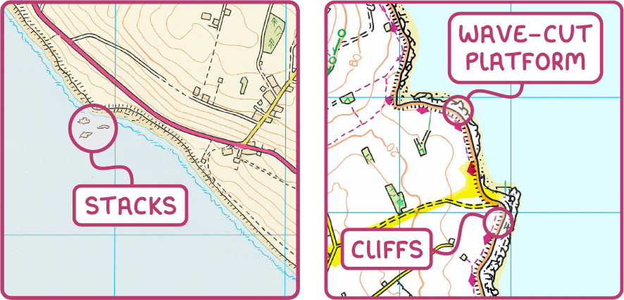
Representation of erosional landforms on maps
- Caves - These are hollowed-out spaces within coastal rocks, often hidden beneath overhangs, and therefore not visible on standard maps.
- Arches - Natural rock formations with an opening through them, typically located below cliff edges, making them invisible on most maps.
- Stacks - Isolated pillars of rock in the sea, shown as small, distinct blobs just offshore on maps.
- Cliffs - Steep rock faces along the coast, depicted as thin black lines indicating sharp elevation changes on maps.
- Wave-cut platforms - Flat or gently sloping rock surfaces at the base of cliffs, represented by irregular, bumpy edges along the coastline on maps.
Identifying depositional landforms on maps
Depositional landforms result from the build-up of sediments along coastlines, creating distinct features that are often easier to identify on maps compared to erosional ones.
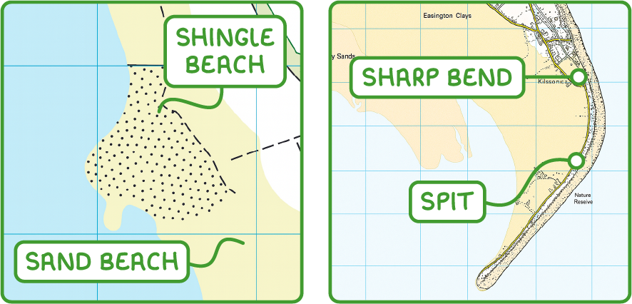
Representation of depositional landforms on maps
- Beaches - Areas of accumulated sand or shingle along the shore, generally marked in yellow on maps.
- Sand beaches - Displayed as pale yellow zones, indicating finer sediment.
- Shingle beaches - Shown as white or yellow areas with speckled patterns, reflecting coarser pebble deposits.
- Spits - Narrow strips of deposited material extending from the coast into the sea, still connected to the mainland at one end. On maps, they appear as elongated beach features projecting outwards, often located at sharp bends in the coastline.
Importance of map reading skills in coastal geography
Map reading is a critical skill in understanding coastal geography, as it allows for the identification and differentiation of various landforms.
Key aspects of map reading for coastal studies
- Distinguishing features - Recognising the difference between erosional and depositional landforms based on map symbols and colours.
- Understanding symbols - Familiarity with specific map representations, such as black lines for cliffs or yellow speckles for shingle beaches, to identify landform types accurately.
- Linking processes to landforms - Interpreting how processes like erosion or deposition create specific features, enhancing comprehension of coastal dynamics.
How were these notes?