6.2 - Collecting & Recording Field Data
Types of data and their importance in fieldwork
Fieldwork in geography involves gathering information to understand physical and human environments. Data collected during fieldwork falls into two main categories, each serving a unique purpose in building a comprehensive picture of the study area.
Categories of data in geographical fieldwork
- Primary data - This is information collected firsthand by the researcher during fieldwork.
- Secondary data - This refers to information obtained from existing sources, not collected by the researcher themselves.
- Quantitative data - Numerical data that can be measured or counted, such as the number of butterfly species in a nature reserve.
- Qualitative data - Non-numerical information that describes characteristics or opinions, such as residents' views on urban development.
Sampling techniques for primary data collection
When collecting primary data, it's often impractical to study an entire area or population. Sampling techniques help researchers select a manageable subset of data that represents the whole, ensuring reliable and unbiased results.
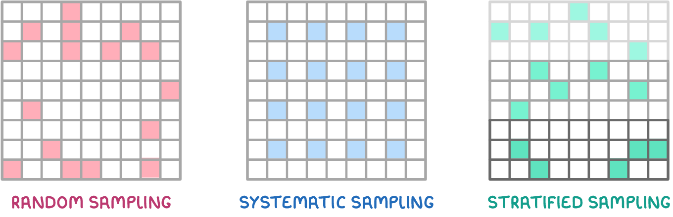
Methods of sampling in fieldwork
- Random sampling - Samples are selected purely by chance, with no specific pattern. For example, collecting rock samples along a mountain trail.
- Systematic sampling - Samples are taken at fixed intervals, which is useful where conditions change frequently, like monitoring temperature at different elevations.
- Stratified sampling - This involves selecting samples from different subgroups to ensure representation across a population, such as gathering opinions on conservation efforts from different age groups.
Tools and methods for accurate data collection
Fieldwork requires specific tools and techniques to ensure data is collected accurately and consistently. The choice of method often depends on the type of investigation and the environment being studied.
Techniques and equipment for data collection
- Measuring gradient - Tools like a clinometer or a pantometer can be used to determine the slope of a landscape.
- Assessing water velocity - In river studies, velocity can be measured by timing how long a buoyant object takes to travel a set distance between two markers.
- Importance of precision - Techniques must be applied with care and consistency to produce reliable results.
- Justifying methods - Researchers should be prepared to explain why a specific data collection method was chosen.
Secondary data sources for investigations
In addition to primary data, fieldwork investigations must incorporate secondary data to provide context and support findings.
Requirements and examples of secondary data sources
- Minimum sources - At least two secondary data sources are required for each investigation.
- Investigation-specific sources - The choice of secondary data depends on the topic being studied:
- Coastal changes and conflicts - Geology maps to understand rock types and erosion patterns.
- River processes and pressures - Flood risk maps to assess areas prone to flooding.
- Dynamic urban areas and changing rural areas - Census data to analyse population trends and settlement changes.
Health and safety considerations in fieldwork
Fieldwork often takes place in challenging or unpredictable environments, making health and safety a critical aspect of planning and execution. A thorough risk assessment is essential to identify and manage potential hazards at study sites.
Steps in conducting a risk assessment
- Identifying risks - Specific hazards at the fieldwork location must be noted.
- Assigning risk ratings - Each identified risk is given a severity score, typically on a scale up to 10, where 10 represents the most dangerous threats.
- Managing risks - Detailed strategies must be documented to mitigate each hazard.